Phobos in Stereo

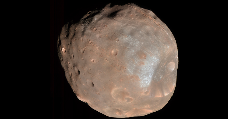
Sometimes I just want to post a kewl image, and this qualifies! The above image of Mars’s moon Phobos stopped me in my tracks this morning, for a multitude of reasons’

First off, it’s color. I don’t recall any earlier color images of Phobos, although I’m too lazy to go check.

Secondly, it’s available in stereo! Which is to say, stereoscopic, not stereophonic. What the rest of the world calls “3D.” This happens to be on my mind, since I’m involved with this crazy construction project, which will eventually house a gorgeous planetarium (of course) as well as a stereoscopic theater. I’m keenly interested in finding content for it, particularly real-world content that isn’t computer-generated. (If you want to watch a video of me from the recent CineGrid conference, you can learn more about my vision for media in the new California Academy of Sciences.)

But lastly, I was especially surprised because the image was taken by the HiRISE camera aboard NASA’s Mars Reconnaissance Orbiter (MRO). HiRISE has taken all kinds of spiffy images of the surface of Mars, but I can only attribute it to a lack of imagination on my part that HiRISE snapping a picture of one of Mars’s moons never occurred to me.

Poisoned Intution

The above image comes from a NASA multimedia piece released the other day. Although the caption doesn’t say so, I’m 99% sure that’s exaggerated terrain. It would be nice if the caption indicated that.

This actually qualifies as one of my “Planetarium Pet Peeves” and thus requires little further complaint on my part. I’ll quote two of my colleagues on the topic, even though their words also appear on the “pet peeves” page…

As Chris Anderson puts it, “When we fly audiences over a vertically exaggerated landscape, we poison their intuition about the way these worlds would actually appear.” Or, as my colleague Carter Emmart has been known to observe, “even Iowa looks mountainous when you exaggerate its terrain by a factor of ten.”

A Decade Apart, But…

Having returned to New York from the American Astronomical Society meeting in Seattle, I thought I might blog about a non-astronomical topic. But then I saw the latest image from the Mars Reconnaissance Orbiter HiRISE camera. Astronomy it is!

The above image (listed under “Topographic Map of Landing Site Region” on the aforementioned HiRISE page) shows the location of the Mars Pathfinder: the HiRISE image forms the background, while the color-coding (in addition to contour lines visible in higher-resolution images than the one above) represents the same topography as reconstructed from the stereo imagery from the Pathfinder itself. So we’re comparing two very different data sets here, collected nearly a decade apart. Normally, false-color imagery makes me wince, but I have to admit that the picture above makes good use of the technique.

You may also recall the famous panoramic image taken by the Mars Pathfinder, and the new HiRISE page offers a variation that shows the Sojourner rover at various points in its exploration of the site. The latter image has labels that match the false-color image above, so you can try to imagine the site from two very different perspectives, in much the same way that an earlier HiRISE image was coupled with Opportunity data.